Scroll to:
Application of Geo-Positioning and Monitoring Technologies for Blocking and Extinguishing Fires in Steppe and Grain Areas
https://doi.org/10.23947/2541-9129-2023-1-47-55
Abstract
Introduction. The relevance of this study is determined by the increasing need to ensure reliable protection of steppe and agricultural territories from possible fires with the help of innovative monitoring methods, the use of fire equipment, fire water supply systems and modern fire extinguishing means. Despite the introduction of new, modern and safe for the environment and people technical solutions aimed at preventing and extinguishing fires, there is still a need to improve the technologies used in the field of fire safety, which is a serious problem for the country.
The work objective is to assess the technical feasibility of effective application of geo-positioning technologies and monitoring based on a set of special devices, model calculation of conditions for reliable fire blocking on steppe and agricultural territories, in particular, in fields with grain areas.
Materials and Methods. The main research methods are the analysis of sources of normative-methodological and scientific-technical information, mathematical modeling, extrapolation to computational and graphic materials, physical experiment.
Results. The data are presented for the development and implementation in the practical activities of fire departments of new technical solutions and technologies for monitoring and extinguishing steppe fires and fires in grain areas, the creation and development of material, technical, methodological and information base for the system of blocking geoecological fires.
Discussion and Conclusion. The analysis of the causes of fires in steppe and agricultural territories allowed us to outline the main methods of their monitoring. Based on the study of prototypes, changes in the technical and layout characteristics of the main elements, a rational solution (know-how) for extinguishing fires in steppe and grain areas is proposed — a tractor-soil-thrower-fire-break maker. At the same time, it is concluded that it is also possible to increase the efficiency of multifunctional tracked or wheeled robotic complexes due to elements of navigation systems (geo-positioning) and monitoring using automatic process control systems.
For citations:
Denisov O.V., Khokhlova K.V., Gribashov M.V. Application of Geo-Positioning and Monitoring Technologies for Blocking and Extinguishing Fires in Steppe and Grain Areas. Safety of Technogenic and Natural Systems. 2023;(1):47-55. https://doi.org/10.23947/2541-9129-2023-1-47-55
Introduction. The analysis of scientific and technical literature revealed a lack of available data on the technical features of extinguishment of steppe fires. Most of these fires (up to 80 % according to various sources) are anthropogenic in nature (violations of fire safety rules when handling open fire and when operating faulty, outdated or not properly maintained equipment). Natural factors of such fires are also known (fires often occur because of a lightning strike during a thunderstorm).
A steppe fire is a naturally or artificially caused fire in steppes. It is produced to displace unwanted plants and destroy dead vegetation in order to improve the herbage. According to the mechanism of fire propagation, a steppe fire is similar to a forest ground fire, but its spread rate is higher, which is due to a number of factors, namely the greater combustibility of dry steppe grasses and a high speed of surface wind in the steppe. Such fires cause significant damage to the natural environment (vegetation and wildlife); can pose danger to people and economic objects1,2 [1, 2].
The causes of fires in steppe and grain areas can also be accidents of ground and air transport, grain harvesting equipment, terrorist acts, military actions and careless handling of open fire. The most fire-hazardous situation develops in late spring and early summer, when the weather is dry and hot. Such fires are characterized by the emergence of one or more islands of fire, which quickly spread to large areas. They have a high speed, reaching 30 km/h at certain moments. This factor is due to the large amount of dry vegetation, ripe cereals and other flammable materials. Steppe fires and grain areas fires pose a huge danger not only to people, but also to farm animals. The fire, which is coming from all sides, exerts strong psychological pressure, thereby can provoke mass panic, which often leads to numerous victims.
The analysis of the use of technical means in extinguishing natural and man-made fires that have occurred in Russia over the past three years has shown that construction and agricultural machinery is actively used for preventive work and extinguishing fires, eliminating their consequences3 [3, 4].
The relevance of the study is also due to the increasing need for the use of advanced equipment and modern devices that ensure fire safety in the steppes and grain areas, when fighting natural fires is complicated by the presence of warehouses with chemicals, for example fertilizers, on the ground [3, 5].
Materials and Methods. Dump trucks and bulldozers are most often used to clear debris, create mineralized strips during steppe and wildfires. The effectiveness of the use of construction and agricultural machinery as special equipment, as well as aerospace exploration and monitoring technologies to ensure fire safety has been proven in practice.
It is possible to increase the efficiency of a multifunctional tracked or wheeled robotic complex due to the elements of navigation systems, the actual technical positioning devices. An example is the Global Russian Navigation Satellite System (GLONASS). This system can broadcast civilian signals anywhere in the country and the world free of charge and without restrictions, with automatic control of monitoring processes. Since the beginning of the 2000s (since the adoption of the federal target program "Global Navigation System"), GLONASS is actively used in preventing and extinguishing geoecological fires.
According to expert estimates, the use of systems and technologies for geo-positioning and monitoring of protected areas will reduce efforts and costs for predicting fire-hazardous situations by 15 %, costs by 20%, as well as reduce the number of personnel required, fire equipment, water or extinguishing agents used. All this together will increase the efficiency of work and provide an opportunity to extinguish fires at night.
Geo-positioning and monitoring technologies will help to increase efficiency due to the task map for differentiated mineralization, plowing and irrigation of steppe territories, presented in Figures 1, 2. Externally, the equipment performing these works does not differ from the usual one.
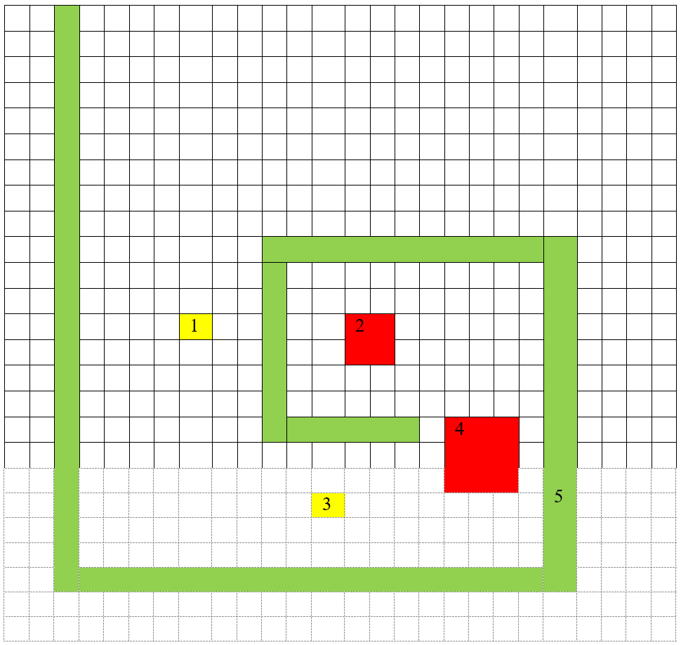
Fig. 1. Simplified map-scheme of the task of monitoring and geoecological zoning of steppe territories and grain areas:1 and 3 — zones with dangerous critical parameters of the environment; 2 and 4 — suspected combustion zones; 5 — the route of the equipment in accordance with the task map
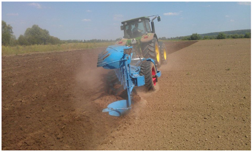 Fig. 2. Work of the equipment for plowing of a given territory [3]
The concept of precise operation of special fire equipment, which is a technology of geo-positioning and monitoring, is based on detailed knowledge of protected areas. It means that in such territories there are areas that are heterogeneous in terms of fire protection, soil and air humidity, ambient temperature, wind direction and speed. These parameters need to be constantly monitored, that is, to carry out their system monitoring. A variant of such a technical complex is shown in Figure 3.
The main task of fire services is to maximize the use of the potential of each local steppe area, optimize the fire equipment and personnel used and, as a result, increase the efficiency of fire extinguishing.
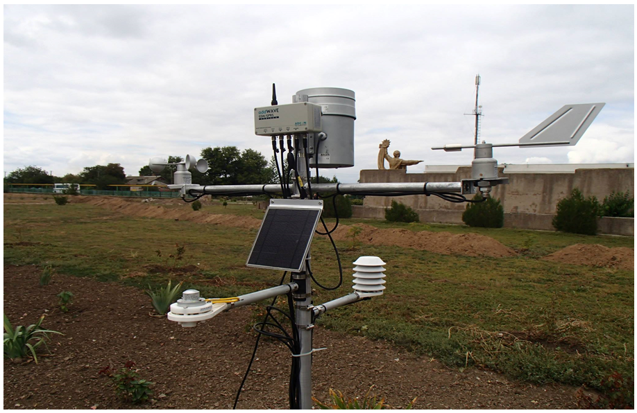 Fig. 3. Weather monitoring system [3]
Accurate cartography for the prevention and extinguishing of fires in steppe and grain areas is necessary in order to calculate, according to the local moistening of the soil layer, how much water or extinguishing agents (EA) will be needed to extinguish fires. Thus, it is possible to estimate the costs of moistening or extinguishing [6, 7]. When using this method, the data on differentiated moistening or extinguishing of areas can also be quickly mapped.
Such cartography is the basis for decision-making, for example, when choosing the type and quantity of necessary firefighting equipment for a given steppe area or grain field. Cartography of steppe and grain areas allows you to:
– save money by local moistening or precise extinguishing of only those areas where it is necessary;
– save time, fuel and lubricants. It is believed that it is possible to scan up to 20 hectares per hour;
– accurately identify fire-hazardous or burning areas;
– use map archives for many years, accumulating experience. Fire-hazardous areas practically do not change over time.
To extinguish steppe fires, fire equipment on tracked or wheeled vehicles is used. It has a wide spectrum of action, has several types. Each type of special tracked firefighting equipment is capable of solving a large number of complex tasks. For this purpose, various types of extinguishing agents are used. Basically, this is water and foam, but in the upgraded machine proposed by the authors, fire extinguishing powders and gases will be additionally used. To supply each of these substances to the fire source, special fire equipment is needed.
Firefighting equipment is designed to extinguish fires of varying complexity with hydraulic guns and hand fire nozzles, as well as to collect and store water and a foaming agent solution, supply water with a certain flow rate, irrigate the cabin during fire extinguishing.
After analyzing several prototypes, as well as changes in the technical and layout characteristics of the main elements of the equipment, a rational solution (know-how) for extinguishing fires in steppe and grain areas is proposed — a tractor-soil-thrower-fire-break maker. The complex of technical solutions includes modifying of the soil-thrower itself, which allows you to partially separate the dry combustible vegetable fraction from the mineral one. In addition, it was found that it is also possible to increase the efficiency of a multifunctional tracked or wheeled robotic complex due to the elements of navigation systems (geo-positioning) and monitoring based on automatic process control systems. It is also assumed, that an improved wheeled or tracked tractor-soil-thrower-fire-break maker equipped with a geonavigation system can also be used to prevent landscape fires, to actively extinguish the edge of steppe or forest ground fires with the help of a mineralized layer of soil and with a minimum volume of dry combustible plant fraction.
Figure 4 shows the main elements of the device. Tractor (1) with enclosing contour (2) consists of frame, suspension mechanism (3), wave-spherical discs forming a crushed soil shaft in front of the milling cutters installed at the level of the bottom of the furrow, support wheels regulating the level of the bottom of the furrow, drive (4) of soil-thrower-fire-break maker (5), bucket-pusher (6) for cutting tree roots and protecting the milling cutters from large obstacles, supporting all-metal wheels to limit the depth of the milling cutters.
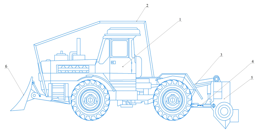 Fig. 4. Wheeled tractor with attachments — soil-thrower-fire-break maker
Protective casing (know-how) consists of two main parts — the protective casing itself and the soil pipeline, made with the possibility of changing its position and separating the combustible plant fraction. In this case, the protective casing is a part of the cylinder surface around the milling cutters. The lower half of the surface of the protective casing is missing, providing the possibility of taking the necessary volume of crushed soil, and the upper part passes into an elliptical or cylindrical surface of the mineral-soil pipeline having a branch for the dry plant fraction. The position and other geometric characteristics of the mineral-soil pipeline can be changed (including automatically) by means of a mechanism for adjusting the angle of its installation by means of a control unit, hydraulic pumps and a number of hydraulic cylinders from the cab of a mobile transport and energy vehicle (tractor, car).
The problem of ensuring fire safety in steppe areas will always be relevant. To improve the process of organizing the extinguishing of fires in steppe and grain areas, it is necessary to carry out many measures, not limited only to the use of heavy special, construction, agricultural machinery for the elimination of fires and their consequences.
The authors have also considered other situations requiring the use of special equipment, in which various machines were studied that performed well in extinguishing natural and man-made fires. As a result, it was determined that such a technique can be widely used both in extinguishing fires in steppe and grain areas, and in fires in fertilizer warehouses.
To calculate the effectiveness of the use of special, construction, agricultural machinery in fires of steppe and grain areas, its tactical and technical characteristics are highlighted and its capabilities are determined.
Results. The most important conditions for ensuring fire safety of steppe and grain areas, along with social ones, are technical and environmental conditions.
Analytical and modeling research methods are used to assess the effectiveness of the use of advanced special, construction, and agricultural machinery in geoecological fires under consideration4[6, 7].
Using the example of an average fire in the grain area, we apply a model calculation of the conditions for reliable blocking of steppe fires.
Let us assume a conditional situation in which the combustion is located near the object of protection. Let us assume that there are about 200 fire-hazardous points in the grain area. The distance from combustion to the place of blocking is 20 meters. The speed of movement of the combustion source carrier is in the range from 3 to 30 m/min. Since the distribution density of the experimentally obtained data was no more than 5 %, it was decided to represent this array by an approximating function. The graphical interpretation is shown in Figures 5 and 6.
Using the principles of "protection by distance and time", we use dimensionless speed and time, risks for personnel engaged in measures to prevent and extinguish steppe fires and fires in grain areas.
The graphs show that with an increase in the speed of movement of the fire front in the grain areas, due to natural factors, and the time of rapid detection and response, the probability of penetration of fire front into critically dangerous points of the object of protection arises.
In this model, such accompanying factors as technical readiness and the condition of special extinguishing agents, the nature of the fire, its changing parameters were not considered. They can influence the probability of successful blocking of the combustion source as well.
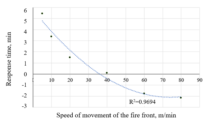 Fig. 5. Graphical dependence of the obtained results on the "protection by distance" principle
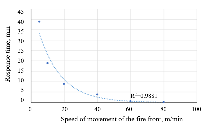 Fig. 6. Graphical dependence of the obtained results on the "protection by time" principle
Due to the developed conditions for reliable blocking of steppe and grain areas fires, developed by one of the authors earlier [3], it is possible to determine the controlled parameters of the fire safety model based on geo-positioning technologies and monitoring of natural parameters.
Discussion and Conclusion. The results of the conducted research show that the problem of fires in steppe and grain areas is very relevant. This is due to the high level of fire and environmental risks of heterogeneous origin [6]. All this allowed us to draw the following conclusions:
– as a result of studying the statistics of fires in steppe and grain areas in the Russian Federation, it was found that over the past 20 years there has been an increase in them;
– based on analytical and modeling research methods, it has been proved that there are effective solutions for reliable blocking of geoecological fires, taking into account the response time, the speed of propagation of the fire front and other factors;
– the design and layout of the main elements of the tractor-soil-thrower-fire-break maker (know-how) are briefly described, which allow you, through constructive analysis, to technically implement reliable blocking of fires in steppe and grain areas;
– it is established that it is possible to increase the effectiveness of fire prevention and extinguishing on the basis of navigation systems and automatic control of monitoring processes in conjunction with mobile transport and energy vehicle (tractor, car) equipped with a ground throwing device.
This area of scientific research is promising and has a high innovative and practical value for improving the fire safety system.
1Technical Regulations on Fire Safety Requirements. Federal Law No. 123-FZ of 22.07.2008. Electronic Fund of Legal and regulatory and technical documents. Available from: https://docs.cntd.ru/document/902111644?section=status (accessed 31.05.2022). (In Russ.).
2On Fire Safety. Federal Law No. 69-FZ of 21.12.1994. Collection of Legislative Acts of the Russian Federation. 2014. No. 5. Article 1. (In Russ.).
3Denisov O. V., Khokhlova K. V., Popko G. A. K razrabotke meropriyatii po preduprezhdeniyu i tusheniyu lokal'nykh pozharov na poligonakh tverdykh bytovykh otkhodov. Aktual'nye problemy nauki i tekhniki: mat. Vserossiiskoi nauch.-prakt. konf. Rostov-on-Don, 2021. P. 136-137. (In Russ.).
4Uspensky I. A. Analiz instrumentov razrabotki tsifrovykh dvoinikov kak sredstv optimizatsii operatsii agropromyshlennogo kompleksa. Perspektivnye tekhnologii v sovremennom APK Rossii: traditsii i inovatsii: mat. 72-i mezhdunar. nauch.-prakt. konf. Ryazan, 2021. P. 437-440. (In Russ.).
References
1. Шишов, С. Г. Характеристика ландшафтных пожаров и их влияние на пожаробезопасность объектов хранения боеприпасов / С. Г. Шишов // Молодежь. Образование. Наука. — 2019. — № 1 (14). — С. 178–204.
2. Andreev, S. S. Ecologic-geographical estimation of climatic comfortness of Rostov-on-Don / S. S. Andreev, E. S. Popova // European Journal of Natural History. — 2013. — No. 5 — P. 32-34.
3. Denisov, O. An innovative approach to the elimination of combustion foci at MSW landfills (on the example Rostov region) / O. Denisov, E. Andreeva // E3S Web of Conferences: Environmental Education and Training of Ecologists. — 2021. — Vol. 273 (78). — 04006. doi: 10.1051/e3sconf/202127304006
4. Bulygin, Yu. The role of hazardous factors of chemical and physical nature in welders` occupational risks management / Yu. Bulygin, E. Andreeva, D. Shoniya // E3S Web of Conferences: Environmental Education and Training of Ecologists. — 2021. — Vol. 273. — 12028. doi: 10.1051/e3sconf/202127312028
5. Andreeva, E. S. Atmospheric air pollution as one of the factors of noncarcinogenic risk to the health of the human population in Rostov-on-Don / E. S. Andreeva, P. V. Klimov, K. S. Shtenske // Geography and Natural Resources. — 2021. — No. 42 (1). — P. 32-36. doi: 10.1134/S1875372821010030
6. Basilaia, M. Cosmoharmonic principles of environmental safety / M. Basilaia, I. Bogdanova, O. Dymnikova // E3S Web of Conferences. Innovative Technologies in Environmental Science and Education. — 2019. — Vol. 135. — 01079. doi: 10.1051/e3sconf/201913501079
7. Пустовая, Л. Е. Анализ и оценка уровня безопасности портовых сооружений на примере склада хранения серы / Л. Е. Пустовая, В. А Чебышева // Безопасность техногенных и природных систем. — 2021. — № 2. — С. 43–49.
About the Authors
O. V. DenisovRussian Federation
Oleg V. Denisov
1, Gagarin Sq.
Rostov-on-Don
Rostov-on-Don
K. V. Khokhlova
Russian Federation
Kristina V. Khokhlova
1, Gagarin Sq.
Rostov-on-Don
Rostov-on-Don
M. V. Gribashov
Russian Federation
Maksim V. Gribashov
1, Gagarin Sq.
Rostov-on-Don
Review
For citations:
Denisov O.V., Khokhlova K.V., Gribashov M.V. Application of Geo-Positioning and Monitoring Technologies for Blocking and Extinguishing Fires in Steppe and Grain Areas. Safety of Technogenic and Natural Systems. 2023;(1):47-55. https://doi.org/10.23947/2541-9129-2023-1-47-55


